Rengali Dam Reservoir,Rengali ,ANGUL
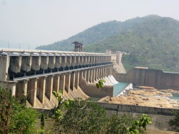
Rengali multi purpose project has been constructed to provide Power Generation, Flood Control and Irrigation facilities. The main component of the project is a masonry gravity dam of 1040 Mt. length, with a maximum height of 75M across river Brahmani near village Rengali in Angul District.
The live storage capacity of the reservoir at F.R.L. is 3412 million cubic meters and its water-spread area at M.W.L. is 414.08 Sq. Km. There is a dam foot powerhouse with installation capacity of 250 MW, 5 units of 50M.W. each. The discharge from each unit varies from 140 cumecs to 170 cumecs.
Through reservoir routing the flood havoc in Dhenkanal, Jajpur & Kendrapara Districts has been redressed significantly. The over all cost of the dam and powerhouse was Rs.200 crores approximately.
The foundation stone was laid by the then Prime Minister Smt.Indira Gandhi on December 23rd,1973. The excavation of dam started in April,1974.On December 12th, 1985 the reservoir was impounded up to Full Reservoir Level. The Rengali masonry-cum-concrete dam constructed across river Brahmani is 1,040m long and maximum height above foundation is 70.50 m. It has 51 blocks for construction purpose. Of these, 24 blocks in the center are spillway blocks provided with radial gates and spillway bridge. There are 8(eight) non-over flow blocks in the right flank and 19 in the left. Block 10 to 14 from the left are power dam blocks through which penstock pipes of 6 m diameter are embedded. The power house is located just down stream of the power dam. This dam connects two hill ranges on in either side of it. The catchment up to Rengali dam is 25,250 km2. The Design flood has been calculated by CWC and adopted Inflow Design Flood(PMF) is 55,540 km2. The maximum routed discharge is 46970 m3/sec when all the 24 radial gates are open. The FRL is at 123.5 m and MWL is at 125.4 m.